Blogia

Terrae Antiqvae

Descubrimiento en Perú daría nuevas pistas de civilización perdida

HuacaPenitenciaria000

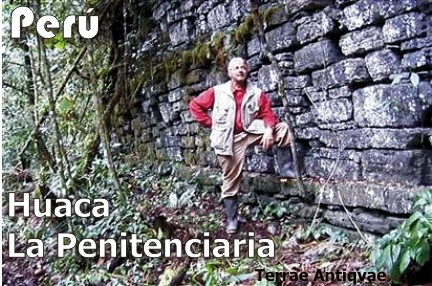
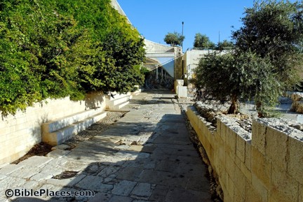
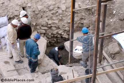
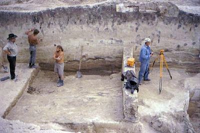
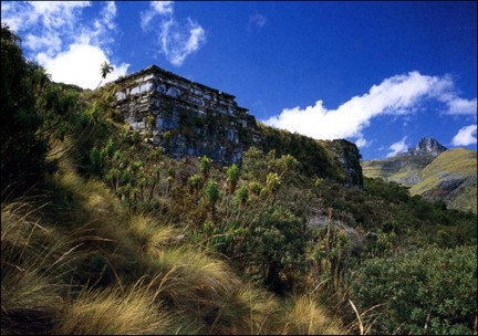
Photo: Researcher Keith Muscutt surveys a wall at the Chachapoya archaeological site known as Huaca la Penitenciaria, or Penitentiary Ruin. Muscutt believes the site may provide clues to the history of the "cloud warriors" who fought against the Inca centuries ago. Keith Muscutt

Una inusual ruina descubierta en las montañas de Perú podría dar nuevas pistas sobre la historia de los habitantes de la cultura Chachapoyas, conocidos como los "guerreros de las nubes" que se enfrentaron al imperio Inca antes de la conquista española.

Keith Muscutt, un británico experto e investigador de la Universidad de California Santa Cruz, dijo este miércoles que el lugar era "notablemente anómalo" por su tamaño, forma y remota ubicación en la densa selva, repleta de monos araña, tucanes y otros animales.

La no fortificada y posiblemente ceremonial estructura está localizada en un área antes considerada la periferia del dominio Chachapoyas, en la región del alto Amazonas.

"Lo que está mostrando es que no sabemos realmente cuál fue su territorio", dijo a Reuters. El lugar donde las ruinas fueron descubiertas es considerado una zona que separa las montañas de Chachapoyas de las culturas de la cuenca del Amazonas.

"Ciertamente no es una fortaleza, entonces, el territorio Chachapoyas se extendió más allá hacia el este o ellos confiaron más en la cooperación que en el conflicto con sus vecinos", dijo.

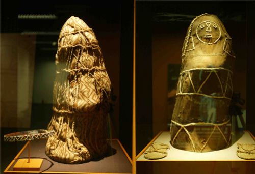
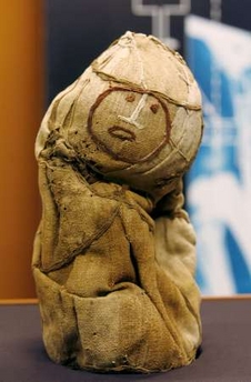
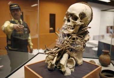
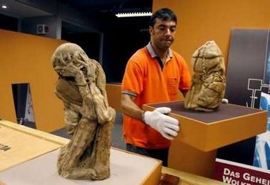
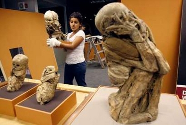
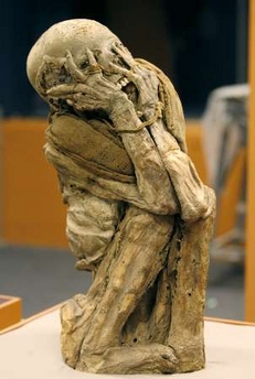
La civilización Chachapoyas, que floreció entre los años 800 y 1475, es conocida por sus ciudadelas ubicadas en lo alto de las montañas como Kuelap o Vira Vira, con momias muy bien conservadas encontradas en tumbas en el Lago de los Cóndores.

Doblegados por los Incas justo antes de la conquista española, los Chachapoyas se aliaron con los europeos después de 1532, pero finalmente cayeron víctimas de enfermedades traídas del viejo continente y desaparecieron.

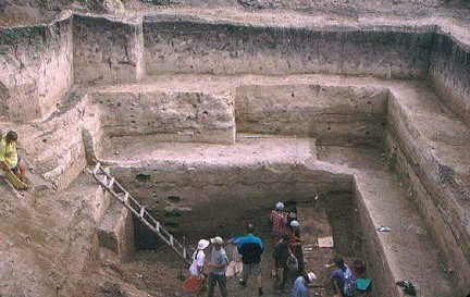
Esta ruina, llamada Huaca la Penitenciaria, consiste en una gran y sólida plataforma ceremonial, una plaza y un número de construcciones rectangulares y circulares.

El lugar, lleno de vegetación, fue descubierto por la familia peruana de exploradores Añazco en una meseta en las montañas entre Río Verde y Río Huabayacu, en el departamento de San Martín, a unos 900 kilómetros al norte de Lima.

En agosto pasado, Muscutt, de 60 años, tomó parte en la expedición liderada por los Añazco, que hizo un reconocimiento preliminar del lugar.

"Mi meta en este punto es notificar a las autoridades peruanas apropiadas", dijo Muscutt, quien está hablando con arqueólogos para evaluar el descubrimiento.

Pese a que se necesita una investigación adicional para confirmar que es una estructura Chachapoyas, Muscutt dijo que tenía un friso ornamental y una albañilería típicos de esa cultura.

"También todas las paredes tienen un leve bulto como el costado de un barril, que creo que es una falla en su ingeniería que ellos adoptaron e hicieron un rasgo, una opción estética", dijo Muscutt.

La ciudad fue abandonada por lo menos hace 400 años.

HuacaPenitenciaria003

"Es una muy interesante cápsula arqueológica del tiempo", agregó.

Fuente: Reuters, Lima, Perú / El Universo, 17 de enero de 2007
Enlace: http://www.eluniverso.com/2007/01/17/
0001/1064/CC7BF9A31F0046F68932E28DF7E54A40.aspx


(2) Anomalous ruins found in Peruvian jungle

Structures may hold clues to history of ancient ‘cloud warriors’

By Andrei Khalip

LIMA, Perú - An unusual archaeological site discovered in Peru’s mountains may hold clues to the history of the Chachapoya people, known as “cloud warriors,” who fought the Inca Empire before the Spanish conquest.

Keith Muscutt, a British-born Chachapoya researcher with the University of California at Santa Cruz, said Wednesday that structures found at the site were “strikingly anomalous” because of their size, shape and remote location in the dense forest full of spider monkeys and toucans.

The unfortified, possibly ceremonial structures are located in an area previously considered on the periphery of the Chachapoya domain in the upper Amazon region.
“What it is showing is that we don’t really know what their territory was,” he told Reuters. The place where the ruins were discovered had been considered a buffer zone between the highland Chachapoya and the tribal cultures of the Amazon basin.

“It is certainly not a fortress, so either the Chachapoya’s territory extended further east, or they relied more on cooperation than conflict with their neighbors,” he said.

Conquered by Incas

The Chachapoya civilization, which flourished between 800 and 1475, is known for its mountaintop citadels, such as Kuelpa and Vira Vira, and its well-preserved mummies found in tombs at the Lake of the Condors.

HuacaPenitenciaria002

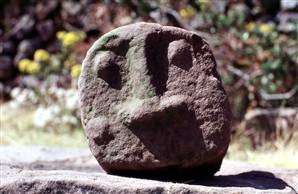
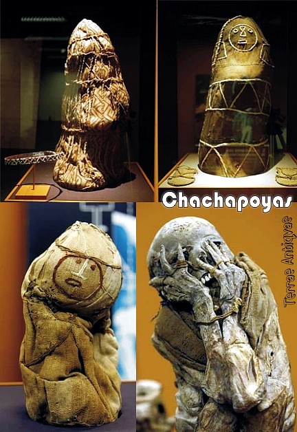
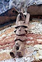
Photo: A Chachapoya stone sculpture is modeled after a human head. Keith Muscutt

Conquered by the Incas just before the Spanish conquest, they allied with the Spaniards after 1532, but fell victim to diseases brought from Europe and vanished.

This ruin, dubbed Huaca la Penitenciaria (Penitentiary Ruin), consists of a large ceremonial platform, a plaza and a number of rectangular and circular buildings.

The heavily overgrown site was discovered by the Anazco family of Peruvian explorers at a plateau in the mountains between the Rio Verde and Rio Huabayacu in the Department of San Martin, about 560 miles (900 kilometers) north of Lima.

Find to be evaluated

In August, Muscutt, 60, took part in an Anazco-led expedition that made a preliminary survey of the site.

“My goal at this point is to notify the appropriate Peruvian authorities,” Muscutt said. He is also talking to archaeologists to evaluate the find.

Although additional research is needed to confirm that it is a Chachapoya structure, Muscutt said it had an ornamental frieze and dry masonry very typical of the Chachapoyas.

“Also, all the walls have a slight bulge to them like the side of a barrel, which I think is a fault in their engineering that they adopted and made a feature — an aesthetic choice resulted from engineering accident,” Muscutt said.

He said the site had been abandoned for at least 400 years. “It is a very interesting archaeological time capsule,” he said.

Source link: Associated Press, Jan. 17, 2007
http://www.msnbc.msn.com/id/16676630/


(3) Pre-Columbian ruin discovered in Peru

Contact: Joshua Weinberg
joshua_weinberg@discovery.com
240-328-3988
Discovery Channel

Find to be featured in Discovery Channel’s new series Chasing Mummies
Silver Spring, Md. -- Explorer Keith Muscutt has announced the existence of a previously unknown pre-Columbian ruin in Peru: the Huaca La Penitenciaría de la Meseta, which will be featured in Discovery Channel’s new series, CHASING MUMMIES, premiering January 2008.

Located in the cloud-forested eastern slope of the Andes mountains, the ruin is believed to belong to the ancient Chachapoya -- a civilization that flourished in the upper Amazon, between its Huallaga and the Marañón tributaries, from about the ninth to the fifteenth century AD. Muscutt delivered the news at the annual Institute for Andean Studies conference (http://www.instituteofandeanstudies.org) at the University of California, Berkeley.

The Chachapoya are renowned for their mountain-top citadels, such as Kuelap, Gran Pajatén and Vira Vira, and for well-preserved mummies recovered from cliff tombs at the Lake of the Condors and Lake Huayabamba. The ruin, consisting of a ceremonial platform (approximately 100 ft. x 200 ft. x 24 ft.) overlooking a plaza (approximately 200 ft. x 300 ft.), as well as numerous rectangular and circular buildings, is of particular interest because of its unprecedented form, size, and the remoteness of the area in which it was found.

First discovered by local pioneers, Octavio, Merlin and Edison Añazco, the site was nicknamed the "Huaca La Penitenciaría" (Penitenciary Ruin) because of its impregnable appearance. News of their discovery was relayed by them to Muscutt who, guided by the Añazcos, arrived at the site and made a preliminary survey of it in August of 2006.

"This is an exciting development for Chachapoya archaeology. The main building is a stepped, rectangular structure made up of three tiers. This building is about two-hundred feet long, a hundred feet wide, twenty-four feet high, and oriented to the cardinal points of the compass. As far as I can tell, apart from some drainage shafts, it’s completely solid. I imagine it served as a ceremonial platform -- a stage for Chachapoya rituals," said Muscutt.

###

Discovery Communications, Inc. is the leading global real-world media company. Discovery has grown from its core property, the Discovery Channel, first launched in the United States in 1985, to current global operations in 170 countries and territories with nearly 1.4 billion cumulative subscribers. DCI’s over 100 networks of distinctive programming represent 27 network entertainment brands including TLC, Animal Planet, Travel Channel, Discovery Health Channel, Discovery Kids, Discovery Times Channel, The Science Channel, Military Channel, Discovery Home Channel, Discovery en Español, Discovery Kids en Español, Discovery HD Theater, FitTV, Discovery Travel & Living (Viajar y Vivir), Discovery Home & Health and Discovery Real Time. DCI’s other properties consist of Discovery Education and Discovery Commerce, which operates more than 100 Discovery Channel Stores in the U.S. DCI also distributes BBC America in the United States. DCI’s ownership consists of four shareholders: Discovery Holding Company (NASDAQ: DISCA, DISCB), Cox Communications, Inc., Advance/Newhouse Communications and John S. Hendricks, the Company’s Founder and Chairman.

Summary of Facts

Discoverers: Octavio, Merlin and Edison Añazco, descendents of the pioneer Benigno Añazco, who first reached and settled La Meseta in the 1980s.

Members of the August 2006 Expedition: Eyner Añazco, Robinson Añazco, Patrocino Añazco, Clever Añazco, Alan Añazco, Merlin Añazco, Edison Añazco, Cheyver Garrido, Keith Muscutt.

Location: La Meseta, a plateau in otherwise mountainous territory, between the Río Verde (also known as Río Chilchos) and Río Huabayacu, both tributaries of the Río Huallabamba, in the Department of San Martín, Peru; approximately 7 degrees South of the Equator, and 77 degrees and 30 minutes West of Greenwich. The village of La Morada, an annex of Chuquibamba, Chachapoyas, Amazonas, is two days on foot or by mule from La Meseta.

Muscutt comments on the structure and design: "It supports the foundations of several rectangular and circular buildings – presumably religious buildings or elite residences. An extension adds another thirty by sixty feet to the main building, making it L-shaped. This has the remains of what might have been a look-out tower on it. Projecting horizontally from the main building, starting about half way up it, is an elevated masonry platform, apparently a plaza, two hundred feet wide, and three-hundred feet long -- roughly the shape and size of a football field. A seam between the main building and the plaza indicates that they were built at different times."

"The plaza has tumbled structures on it too, although these look somewhat improvised, so I wonder if they were part of the original design. After centuries of overgrowth as well as damage from frequent earth tremors (the area was hit by a 7.5 Richter-scale earthquake as recently as 2005) it’s hard to trace the outlines of these buildings. At the far end of the plaza, the ground rises up to the level of its surface, and it gradually transforms into a maze of low stone walls that look like the results of clearing land for agriculture. Overlooking the plaza, the upper facade of the main building incorporates a typical Chachapoya frieze consisting of two parallel rows of recessed masonry, so there’s no doubt in my mind that this is Chachapoya handiwork; but without the architectural detail I wouldn’t be sure what culture to attribute it to. There’s only one Chachapoya building that even remotely resembles it. That’s Pirca Pirca, near Chivani, above tree line at around 11,000 feet – a far cry from La Penitenciaría, which is 6,000 feet above sea level, with spider monkeys in the forest canopy. Other than Pirca Pirca, and now La Penitenciaría, almost all known Chachapoya buildings are round or curvilinear. With the exception of the colossal retaining wall of the Chachapoya citadel, Kuelap, I can’t think of a Chachapoya engineering project as ambitious as La Penitenciaría. Over 25,000 cubic yards of dressed stone and rubble were needed to build it."

"It’s totally unexpected that such a massive monument would show up on the periphery of Chachapoya territory, in an area that has usually been thought of as a buffer zone between the highland Chachapoya and the tribal cultures of the Amazon Basin. But La Penitenciaría was definitely not a fortress -- so either their territory extended further East, or the Chachapoya relied more on cooperation than conflict with their neighbors. Compounding the puzzle, there don’t seem to be any other buildings in the immediate vicinity. Unlike most ceremonial platforms in the Americas, it doesn’t seem to be the nucleus of a population center. It just sits there in the middle, or the edge, of nowhere. Like London Bridge in Arizona – it’s really there, but very hard to fathom. Someone put a tremendous amount of energy into Huaca La Penitenciaría de la Meseta’s construction, but exactly who, why, and when is anybody’s guess. My own guess is that it had something to do with ancient coca leaf production at La Meseta. But for the time being it’s an architectural and archeological enigma -- one that promises to open a new chapter in the history of the Chachapoya."

Elevation: 2,000 meters above sea level (approx. 6,000 feet).

Natural Environment: Lower mountain cloud forest. High rainfall and humidity. Vegetation: trees, thorny shrubs, bamboos, palms, vines, bromeliads, orchids, tree-ferns. Large animals include jaguar, spectacled bear, spider monkey. Birds include toucans, turkeys and parakeets.

Cultural Affiliation: Chachapoya

Date: 850AD to 1475AD.

Who were the Chachapoya?: An agriculturally-based, stone-building, metal-working culture that occupied the highlands and the cloud forests, or "ceja de la montaña" (eyebrow of the jungle), along the spine of the Andes, between the Marañón and Huallaga drainages, in North-Eastern Peru. They flourished for several centuries, probably acting as middle-men in the trade of items such as coca leaves and feathers between the lowland tribes and the coastal civilizations. They were overwhelmed by the Inca empire in the late 15th century. Always rebellious, they quickly allied themselves with Spanish conquistadores to throw off the Inca yoke, but they themselves soon fell victim to European epidemic diseases. Their population decimated, their culture disappeared entirely except for the ruins and artifacts they left behind. Archaeological research into the Chachapoya is scant. Scarcity of scientific information about them has unfortunately caused them to become the object of much speculation and fantasy – with unsubstantiated reports of vast Chachapoya metropolises, claims that the Chachapoya realm was El Dorado, and so forth. They have also been fictionalized in Clive Custler’s novel "Inca Gold."

Keith Muscutt

Keith Muscutt, a British citizen resident in Santa Cruz, California, USA, was born in England and educated in England (Oundle School and University of Sussex) and the USA (Phillips Andover and UC Davis). He is the author/photographer of an illustrated book about the Chachapoya "Warriors of the Clouds: A Lost Civilization of the Upper Amazon of Peru." His expeditions to find, study and conserve ancient Chachapoya remains were the subject of a two-hour History Channel documentary "Cliff Mummies of the Andes." He has been exploring the upper Utcubamba, Pusac, Huabayacu, Huayabamba, Yonan, Huambo, Imaza, and Lejia drainages, in the Peruvian Departments of Amazonas, San Martín and La Libertad since 1981. Among the sites he was the first to document are: the walled citadel of Vira Vira; Pampa Hermosa; and the cliff tombs of Laguna Huayabamba, Cueva de Osiris, Casa de Oro, Brillante Luna, Tres Ojos, and Casa Blanca. He was a member of the official reconnaissance expedition that recorded the looted Chachapoya-Inca burial sites at the Lake of the Condors. Founder of an NGO, Fundacíon Benéfica Niños Pobres de Chuquibamba, he is Assistant Dean of the Arts at UC Santa Cruz, a member of the Institute for Andean Studies, and a Research Associate of the Museum of Man in San Diego.

Source link: Joshua Weinberg / Discovery Channel / Eurekalert, 17-Jan-2007
http://www.eurekalert.org/pub_releases/2007-01/dc-prd011707.php


Penitenciaria 1

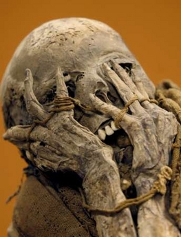
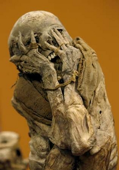
"The Penitentiary" Keith Muscutt, an independent researcher, heard about the discovery of an ancient Peruvian ruin, pictured here, and recently explored the site, which will make its television debut on the Discovery Channel's new "Chasing Mummies" series early next year. Nicknamed "The Penitentiary," the site is thought to contain Inca Empire-era mummies. Keith Muscott

Penitenciaria 2

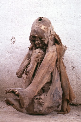
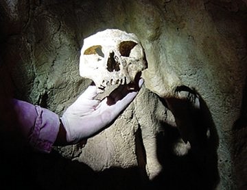
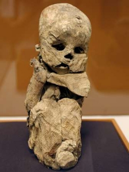
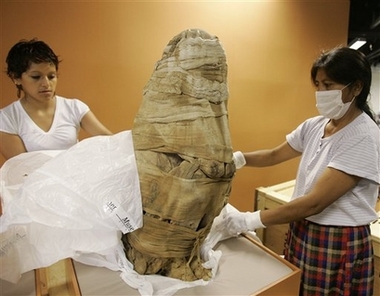
Mummy of La Petaca. The preserved body pictured here was unearthed in an Andean region known for its mountainside tombs. A nearby ruin, nicknamed "The Penitentiary," may contain similar mummies. The ruin will appear on the Discovery Channel's new "Chasing Mummies" series in 2008. Keith Muscott


Descubren el barranco que contuvo la invasión de los romanos en Jerusalén

jerusalen003

Photo: Valley Cardo near Dung Gate (south of excavation area). Todd Bolen – Bible Places Blog.

Arqueólogos de la Dirección de Antigüedades de Israel han descubierto en la ciudad vieja de Jerusalén el barranco que, suponen, contuvo durante un mes la conquista del barrio judío después de la destrucción del Segundo Templo en el año 70 d.C.

'Este pudo haber sido un obstáculo natural, por la topografía, para la legión romana', que invadió Jerusalén en aquel año, 'y ha sido el descubrimiento más impresionante' en zona de Templo, indicó la directora de las excavaciones, Shlomit Wexler-Bedolaj, al diario 'Jerusalem Post'.

Otro descubrimiento se produjo en el lecho del elevado barranco, donde encontraron un nuevo tramo de la vía del Cardo con su ancho original, de once metros, que construyeron los romanos y que cruzaba Jerusalén de norte a sur.

Parte del pavimento del Cardo, bordeado por columnas, fue hallado durante excavaciones anteriores y rehabilitado para servir como atracción turística por las autoridades israelíes, una suerte de 'avenida' flanqueada por locales comerciales como en la Edad Media.

El comienzo del Cardo estaba en el que desde hace más de 500 años es el portal de Damasco, en la muralla que rodea la ciudad vieja y que edificó Suleimán el Magnífico tras la conquista musulmana de Jerusalén en el siglo VII d.C.

'Estas excavaciones nos permiten estudiar un importante capítulo en la historia milenaria de Jerusalén, paso a paso y período por período', dijo la directora.

Fuente: Terra Actualidad – EFE, 15 de enero de 2007
Enlace: http://actualidad.terra.es/sociedad/articulo/
descubren_jerusalen_barranco_contuvo_invasion_1329361.htm


(2) Invading Romans' greatest obstacle uncovered in J'lem

By ETGAR LEFKOVITS, Jan. 15, 2007

jerusalen002

Photo: (Yellow box = present excavations; red box = Byzantine Valley Cardo previously revealed). Todd Bolen – Bible Places Blog.

Antiquities Authority archeologists describe the important discoveries uncovered opposite the Temple Mount at a press conference on Sunday. Photo: Israel Antiquities Authority.

An immense bedrock cliff uncovered opposite Jerusalem's Temple Mount may help explain why it took the Romans so long to capture what is now known as the Jewish Quarter almost two millenia ago, an Israeli archeologist said Sunday.

The cliff, uncovered during a year-long excavation at the western edge of the Western Wall Plaza, was one of several important finds that include the remains of a colonnaded street called the Eastern Cardo, dating from the Roman-Byzantine period; a section of the Lower Aqueduct that conveyed water from Solomon's Pools to the Temple Mount; and a damaged rock-hewn and plastered Jewish mikve (ritual bath) that dates back to the Second Temple period, the Israel Antiquities Authority announced at a press conference.

jerusalen004

Photo: In the close-up below, it looks like large hewn slabs (paving stones?) have been removed in order to excavate beneath them. Todd Bolen – Bible Places Blog.

The dig, which was conducted in an area that had not been excavated before due to plans for construction, also served to clarify the height of an immense bedrock cliff that separated the Upper City from the Temple Mount area. It in itself is "the most impressive" find, said Shlomit Wexler-Bedolah, the excavation director.

Wexler-Bedolah said the cliff's topography could help explain the slow Roman conquest, noting that it took the Roman army an entire month from the time they destroyed the Temple Mount on the ninth day of the Hebrew month of Av until they captured the ground of today's Jewish Quarter on the 10th day of the following month.

"This could have been a natural obstacle for the Roman army," she said.

jerusalen01ta

Jerusalem regional archeologist Jon Seligman focused on the significance of the road that was uncovered at the foot of the cliff - an elaborate colonnaded street known as the Eastern Cardo.

The street, which began at the Damascus Gate, ran the length of the Tyropoeon Valley channel. Sections of the street had previously been uncovered in the northern part of the Old City, on Rehov Ha-Gai and west of the Dung Gate.

Wexler-Bedolah said the current excavation exposed for the first time the full 11-meter width of the original road, which had been paved in the Roman manner with large flagstones set in place diagonally, probably to prevent wagons from slipping. A drainage system had been installed below the flagstones, she said.

A complex of shops and buildings constructed on the spot in the Middle Ages continued to exist through the Ottoman period and constituted part of the Mughrabi Quarter that stood at the site until 1967.

jerusalen005

Photo: My guess is that those large paving slabs are part of the Byzantine "Valley Cardo," which has been discovered to the south. Todd Bolen – Bible Places Blog.

"This excavation allows us to learn an important chapter in thousands of years of history, stage after stage and period after period in the existence of this city," Wexler-Bedolah said.

The newly found remnants of the capital's past will be preserved underneath the new Western Wall Heritage Center, which is slated to be built at the site and whose planning sparked the "rescue (or salvage) dig." The center, whose construction is expected to take several years and is being underwritten by US media mogul Mort Zuckerman, will include an educational center, a video conference room, a VIP lounge and a police station, said Rabbi of the Western Wall Shmuel Rabinovitch.

There have never been any archeological excavations on the Temple Mount itself due to the site's holy status for both Jews and Muslims.

Source link: http://www.jpost.com/servlet/Satellite?cid=
1167467733044&pagename=JPost%2FJPArticle%2FShowFull

Un estudio revela la evolución morfológica de los primeros europeos

PesteraCráneoOase000

Foto: El cráneo Oase2 tiene una frente plana y molares superiores excepcionalmente desarrollados, típicos del hombre de Neandertal (Foto: Cortesía Universidad de Washington)

Un cráneo de 'Homo sapiens' de hace 40.000 años revela el cruce de especies

Los primeros seres humanos modernos que llegaron desde África hace unos 40.000 años continuaron evolucionando en su contacto con los neandertales, reveló un estudio difundido por la revista 'Proceedings of the National Academy of Sciences'.

Un grupo de científicos ingleses, estadounidenses y europeos comparó los rasgos físicos en los restos de cráneos de los primeros seres humanos modernos hallados en 2003 en la caverna Pestera Cu Oase, en el sudoeste de Rumanía, con otras muestras del mismo período del Pleistoceno.

"Las diferencias entre los cráneos sugieren una compleja dinámica demográfica a medida que los seres humanos modernos se dispersaban en Europa", indicó el estudio.

Un grupo de fragmentos craneanos, identificado como Oase 2, registró una antigüedad de más de 35.000 años, en tanto que los de Oase 1, que consisten en una mandíbula, tenían una antigüedad de más de 40.500 años.

Esos dos fósiles tenían más o menos la misma edad y constituyen el conjunto craneano de un ser humano moderno más antiguo que haya sido encontrado jamás en Europa, así como la mejor prueba de su apariencia, indicó el estudio.

Un informe publicado la semana pasada por la revista 'Science' señaló que los primeros seres humanos modernos se establecieron en el este de Europa, a orillas del río Don, tras llegar procedentes del África subsahariana hace unos 45.000 años.

Los científicos indicaron en la revista 'National Proceedings of the National Academy of Sciences' que una comparación de los fragmentos craneanos rumanos con otros cráneos reveló características de seres humanos actuales y también de neandertales.

Sin embargo, también tenían importantes características que no se presentan en la estructura ósea de la cabeza de seres humanos modernos.

Estas diferencias incluyen un achatamiento frontal, una protuberancia mastoidea bastante grande, así como molares superiores con una progresión en el tamaño que es característica de los neandertales.

Según Joao Zilhao, profesor de la Universidad de Bristol, en el Reino Unido, las diferencias plantean importantes interrogantes acerca del desarrollo morfológico de los seres humanos.

"Podrían ser resultado de una regresión evolutiva o el reflejo de una muestra paleontológica incompleta de la diversidad humana en el Paleolítico Medio", señaló.

Pero también podrían ser una prueba de una mezcla con las poblaciones neandertales a medida que esos seres humanos se propagaban a través de Europa occidental, agregó.

Esta combinación pudo haber tenido como resultado características arcaicas conservadas de los neandertales y combinaciones especiales que surgieron de la mezcla de rasgos procedentes de diferentes conjuntos genéticos, señaló el científico.

Según Zilhao, la resolución final de estos interrogantes deberá esperar el estudio de otras muestras fósiles de los primeros seres humanos que poblaron Europa, así como de otros especímenes que intervinieron en su evolución morfológica.

No obstante, señaló que el estudio de los cráneos de Rumanía se suma a un conjunto ya existente de pruebas fósiles, genéticas y arqueológicas que indican una importante interacción biológica y cultural entre los seres humanos modernos y las poblaciones anatómicamente arcaicas, incluyendo los neandertales, con las que se iban encontrando en su avance hacia Europa occidental.

Según Erik Trinkaus, profesor de antropología de la Universidad de Washington, el hallazgo de los restos craneanos en Rumanía es una muestra de la evolución permanente del ser humano.

CráneoOase001

"Técnicamente, se trata del cráneo de un ser humano. Pero los seres humanos, tal y como los conocemos ahora, han evolucionado de manera considerable desde entonces", señaló.

Fuente: EFE / El Mostrador.cl, 16 de enero de 2007
Enlace: http://www.elmostrador.cl/modulos/noticias/
constructor/noticia_new.asp?id_noticia=207747


Más información:

ERIK TRINKAUS
http://www.artsci.wustl.edu/~anthro/blurb/b_trink.html

(2) Skull suggests human-Neanderthal link

Interbreeding may have occurred thousands of years ago

By Randolph E. Schmid

WASHINGTON - A skull found in a cave in Romania includes features of both modern humans and Neanderthals, possibly suggesting that the two may have interbred thousands of years ago.

CráneoOase002

Neanderthals were replaced by early modern humans. Researchers have long debated whether the two groups mixed together, though most doubt it. The last evidence for Neanderthals dates from at least 24,000 years ago.

The skull bearing both older and modern characteristics is discussed in a paper by Erik Trinkaus of Washington University in St. Louis. The report appears in Tuesday's issue of Proceedings of the National Academy of Sciences.

The skull was found in Pestera cu Oase — the Cave with Bones — in southwestern Romania, along with other human remains. Radiocarbon dating indicates it is at least 35,000 years old and may be more than 40,000 years old.

The researchers said the skull had the same proportions as a modern human head and lacked the large brow ridge commonly associated with Neanderthals. However, there were also features that are unusual in modern humans, such as frontal flattening, a fairly large bone behind the ear and exceptionally large upper molars, which are seen among Neanderthals and other early hominids.

CráneoOase003

"Such differences raise important questions about the evolutionary history of modern humans," said co-author Joao Zilhao of the University of Bristol, England.

It could reflect a case in which ancient traits reappear in a modern human, or it could indicate a mixture of populations, Zilhao said. Or it simply may be that science hasn't been able to study enough early modern people to understand their diversity.

PesteraCráneoOase004

Dr. Richard Potts of the Smithsonian's National Museum of Natural History noted that the skull represents the earliest modern human ever found in Europe.

It's a big deal in that sense, he said, but the combination of characteristics don't necessarily indicate interbreeding between populations.

Overall there is no strong evidence for mixing of Neanderthal and modern human populations and "this doesn't add any," said Potts, who wasn't part of the research team.

None of the features cited as unusual in modern humans is exclusively Neanderthal, Potts said. Rather, they could be features passed down from earlier populations in Africa.

CráneoOase004

Photo: This skull, found in Pestera cu Oase — the Cave with Bones — in southwestern Romania, includes features of both modern humans and Neanderthals, possibly suggesting that the two hominid species may have interbred thousands of years ago. National Academy Of Sciences / AP

The field work that uncovered the skull was conducted in 2004 and 2005.

Meanwhile, a research team led by Svante Paabo of the Max Planck Institute for Evolutionary Anthropology in Leipzig, Germany, is trying to map the Neanderthal genome in hopes of better understanding any possible relationship to modern people.

The research was funded by the U.S. National Science Foundation, the Wenner-Green Foundation, Washington University, the Leakey Foundation, the Portuguese Institute of Archaeology, the Royal Belgian Institute of Natural Science, the Romanian National Council for Academic Research and the Foundation Fyssen.

Source link: The Associated Press. Jan. 15, 2007

http://www.msnbc.msn.com/id/16639881/

Los últimos hallazgos avalan la tesis del Hombre Orce, el primer europeo

Hombre Orce Gibert

El reciente hallazgo del esqueleto de una niña en Tarragona de hace 2.000 años, cuyo cráneo es idéntico al encontrado en el yacimiento arqueológico de Orce (Granada) constituye, según el paleoantropólogo José Gibert, la prueba de que éste es humano y, por tanto, el primer poblador de Europa Occidental.

El fósil del llamado «hombre de Orce» fue encontrado en 1982 por el paleontólogo catalán José Gibert en el Norte de la provincia de Granada, momento desde el cual se abrió un amplio debate, tanto científico como público, que cuestionaba si esta pieza pertenecía a un humano o un équido.

Estos fueron algunos de los datos expuestos ayer por Gibert tras sus últimas investigaciones, que evidencian además a su juicio que los yacimientos arqueológicos de Orce son «los más viejos de la Europa occidental», lo que favorecería otro tipo de hipótesis sobre los modelos de dispersión de los homínidos.

El paleoantropólogo Gibert explicó que un grupo de expertos encontraron hace unos meses en Tarragona el esqueleto de una niña romana de hace 2.000 años, cuyo fragmento craneal es igual al cráneo del homínido encontrado en los yacimientos arqueológicos de Orce.

En concreto, Gibert señaló que el cráneo del «hombre de Orce» cuenta con una pequeña cresta, anomalía que también se encuentra en el caso de la niña de una forma más pronunciada. El paleoantropólogo destacó que este hallazgo, publicado internacionalmente en revistas de prestigio como Quaternary Sciencies Review , constituye una «prueba clara» de la humanidad del «hombre de Orce», por lo que, dijo, a partir de aquí «se acaba la polémica sobre el asunto».

Por otro lado, el sedimentólogo y especialista en magnetoestratigrafía Luis Gibert, hijo del paleoantropólogo, señaló que los yacimientos de Orce son «los más antiguos de Europa Occidental», de acuerdo con las últimas investigaciones realizadas, que apuntan a que los yacimientos de Orce tienen una edad mínima de 1.300.000 años y «no un millón como se pensaba en el año 1998».

Jose Gibert Orce

El paleomagnetismo y la sedimentología fueron las técnicas utilizadas para estas dataciones, que comenzaron a desarrollarse desde 1998 en colaboración con el Berkely Geochronology Center, laboratorio que ha datado los restos arqueológicos de lugares como África Java o Georgia.

De acuerdo con los métodos utilizados, Gibert señaló que el yacimiento más antiguo de los existentes en Orce sería el de Venta Micena, al que se le puede asignar una edad mínima de 1.300.000 años, seguido del de Barranco León, al que se le ha asignado una edad de 1.250.000 años, mientras que el más moderno sería el de Fuente Nueva Tres, que tiene 1.200.000 años.

Fuente: JUAN FERRERAS / Diario de León, 16 de enero de 2007
Enlace: http://www.diariodeleon.es/se_
cultura/noticia.jsp?CAT=114&TEXTO=5457552


(2) Gibert dice que los últimos hallazgos avalan la tesis del Hombre de Orce, primer homínido en Europa

El reciente hallazgo del esqueleto de una niña en Tarragona de hace 2.000 años, cuyo cráneo es idéntico al encontrado en el yacimiento arqueológico de Orce (Granada) constituye, según el paleoantropólogo José Gibert, la prueba de que éste es humano y, por tanto, el primer poblador de Europa Occidental.

El fósil del llamado "hombre de Orce" fue encontrado en 1982 por el paleontólogo catalán José Gibert en el Norte de la provincia de Granada, momento desde el cual se abrió un amplio debate, tanto científico como público, que cuestionaba si esta pieza pertenecía a un humano o un équido.

Estos fueron algunos de los datos expuestos hoy en rueda de prensa por Gibert tras sus últimas investigaciones, que evidencian además a su juicio que los yacimientos arqueológicos de Orce son "los más viejos de la Europa occidental", lo que favorecería otro tipo de hipótesis sobre los modelos de dispersión de los homínidos.

El paleoantropólogo Gibert explicó que un grupo de expertos encontraron hace unos meses en Tarragona el esqueleto de una niña romana de hace 2.000 años, cuyo fragmento craneal es igual al cráneo del homínido encontrado en los yacimientos arqueológicos de Orce.

En concreto, Gibert señaló que el cráneo del "hombre de Orce" cuenta con una pequeña cresta, anomalía que también se encuentra en el caso de la niña de una forma más pronunciada.

El paleoantropólogo destacó que este hallazgo, publicado internacionalmente en revistas de prestigio como Quaternary Sciencies Review, constituye una "prueba clara" de la humanidad del "hombre de Orce", por lo que, dijo, a partir de aquí "se acaba la polémica sobre el asunto".

Por otro lado, el sedimentólogo y especialista en magnetoestratigrafía Luis Gibert, hijo del paleoantropólogo, señaló que los yacimientos de Orce son "los más antiguos de Europa Occidental", de acuerdo con las últimas investigaciones realizadas, que apuntan a que los yacimientos de Orce tienen una edad mínima de 1.300.000 años y "no un millón como se pensaba en el año 1998".

El paleomagnetismo y la sedimentología fueron las técnicas utilizadas para estas dataciones, que comenzaron a desarrollarse desde 1998 en colaboración con el Berkely Geochronology Center, laboratorio que ha datado los restos arqueológicos de lugares como África Java o Georgia.

De acuerdo con los métodos utilizados, Gibert señaló que el yacimiento más antiguo de los existentes en Orce sería el de Venta Micena, al que se le puede asignar una edad mínima de 1.300.000 años, seguido del de Barranco León, al que se le ha asignado una edad de 1.250.000 años, mientras que el más moderno sería el de Fuente Nueva Tres, que tiene 1.200.000 años de existencia.

Este hallazgo supone que el yacimiento de Orce existió "medio millón de años antes que el de Atapuerca" (Burgos) lo que a su vez, favorece otros planteamientos sobre los modelos de dispersión, según informó Gibert, quien señaló la posibilidad de que los homínidos "cruzaran el Estrecho de Gibraltar en su desplazamiento".

Al ser interrogado sobre el expediente que le abrió la Junta años atrás por excavar en zona no autorizada, Gibert señaló que "está recurrido" en el Tribunal Superior de Justicia de Andalucía (TSJA) a la espera de que salga una sentencia en breve plazo, y añadió que en la actualidad cuenta con el apoyo de la Diputación de Barcelona, que le ha facilitado diversos documentos que "serán claves para este juicio".

En esta línea señaló que próximamente se presentarán dos nuevos proyectos para continuar las investigaciones en la zona de Orce y solicitó a la Junta, que le retiró el permiso para excavar, que éstos sean valorados por científicos independientes para que así puedan comenzar a trabajar en verano.


Fuente: RADIO GRANADA, http://www.radiogranada.es, 16 de enero de 2007
Enlace: http://www.radiogranada.es/modules.
php?name=News&file=article&sid=34682


(3) Los restos de Orce son humanos, de 1.300.000 años y los más antiguos de Eurasia según Gibert. El profesor considera que los nuevos datos "se cierra la polémica"

Desde 1995 ya apenas se discute acerca de la naturaleza humana de los restos de Orce. La idea de que se trataba de una “quijada de asno”, quedaba entonces desterrada por el aval de la comunidad científica en el Congreso Internacional de Paleontología Humana en Orce, con la presencia de 300 científicos de 18 nacionalidades y aunque aún se ha mantenido oposición a este descubrimiento por parte de algunos investigadores, el profesor José Gibert Clols, paleontólogo especialista en fauna y homínidos del Cuaternario que, además lleva 30 años estudiando los restos de Orce, afirma que con las nuevas pruebas determinadas recientemente, “se cierra definitivamente la polémica”. Los restos son humanos y tienen una antigüedad de 1.300.000 años, medio millón de años más que los de Atapuerca, con lo que estaríamos antes los restos más antiguos de Europa Occidental y un replanteamiento sobre la entrada de los primeros homínidos, procedentes de África, en Europa.

Los principales problemas a resolver en cuanto a los restos encontrados en 1982 eran primero, definir la naturaleza de los restos, definir la especie y determinar la edad de los yacimientos.

SON HUMANOS

En cuanto a la naturaleza humana del “Hombre de Orce”, el descubrimiento del esqueleto completo de una niña romana en Tarragona ha aportado una prueba más, más concluyente si cabe según el profesor Gibert, sobre la “humanidad” del resto granadino. Esta misma afirmación ya fue respaldada por el que fuera primer director de las excavaciones de Atapuerca, Emiliano Aguirre que, tras la comparación con los restos de Tarragona declaró que suponía “una palpable evidencia” que suponía un “espaldarazo y prueba evidente” de lo defendido por Gibert desde el principio.

Orce002

El análisis del cráneo de la niña de Tarragona que vivió hace 2.000 años, revela que “la parte de arriba es igual al de Orce”, en cuanto a la cara interna, ambos coinciden con la presencia “idéntica” de una cresta que, resulta incluso algo más elevada en el resto de Tarragona. Este hallazgo, que ha sido debido al Dr. Doméne Campillo y colaboradores, respalda el cráneo infantil de Orce como los del “hombre más antiguo de Eurasia”, ya que anteriormente se consideraba que dicha "cresta" no era compatible con el género ’homo’, lo que ahora se demuestra que sí.

LOS RESTOS MÁS ANTIGUOS DE EURASIA

En el año 2000 ya los doctores Oms, Agustí, Martínez-Navarro, Toro y otros, publicaron las edades de los yacimientos de Orce determinadas por paleomagnetismo, una técnica que permite aportar datos rigurosos sobre las edades de los depósitos geológicos en base a la polaridad magnética de los estratos limitados entre distintas magnetozonas. Conocida la secuencia de la polaridad se hace una correlación con la Escala Global Temporal Paleomagnética (GPTS).

Los datos arrojados en la investigación del 2000 aportaba edades muy imprecisas y ambiguas que oscilaban entre los 0.8 y los 2.5 millones de años, aunque los autores del estudio apuntaban una edad de 1 millón de años, siendo esta datación la que finalmente trascendió internacionalmente.

En 1998 se estableció una importante colaboración con el Berkley Geochronology Center en la persona del profesor Gary Scott que había trabajado en la datación de yacimientos con presencia humana tan importantes como los de Java, África o Georgia (Dmanisi). En 2006, la publicación de los resultados en Quaternary Sciences Rewiew se establece una edad de 1.300.000 años.

EL VALOR DE ORCE

Entre las conclusiones que se exponen a la luz de estos datos está el de poder incluir Orce entre los únicos 3 yacimientos de Europa Occidental con edades más antiguas de 1 millón de años. El de Pirro Nord en Italia de escasos vestigios líticos y sin restos humanos, con una datación de 1.3 millones de años determinada únicamente por la fauna. El de Cueva Victoria en Cartagena, que contiene restos humanos y se ha determinado su edad por paleomagnetismo y, finalmente los de Orce, con cuatro estos humanos y abundancia y variedad de industria lítica, huesos rotos por percusión, estrías de descarnación, etc.

El resto de los yacimientos europeos, incluido la Sima del Elefante en Atapuerca, no superan el millón de años, los restos de actividad humana es limitada en general y carecen de restos humanos.

Orce001

Gibert considera que la edad de los yacimiento de Orce “es clave para que Orce sea hegemónico entre los restantes yacimientos de Europa Occidental” y, especialmente destaca que de los 3 yacimientos que superan el millón de años, dos estén en España, “datos importantes para acreditar la marca del “primer europeo”.

Finalmente, la constatación de estas edades y restos humanos, que han sido publicados y avalados por prestigiosas revistas a nivel mundial, obliga a mirar de nuevo los modelos de dispersión de nuestros antepasados fuera de África y, en este sentido a partir de ahora, Orce tendrá que ocupar el papel que le corresponde y que hasta ahora había sido “relegado al olvido”.

AVAL DE LA COMUNIDAD CIENTÍFICA

Gibert insistido en el reconocimiento que se concede a las investgaciones realizadas en Orce por parte de la comunidad científica internacional, y ha destacado las numerosas publicaciones especializadas que se suman a la confirmación de la humanidad de los restos de Orce.

El profesor ha pèdido que le "permitan seguir investigando", y ha anunciado que va a presentar dos proyectos de investigación a la Junta, de la que espera su apoyo a la vista de los nuevos datos en lugar de la denegación que tuvieron anteriormente por considerar "erróneas" sus investigaciones.

Gibert ha manifestado su deseo de poder trabajar en Venta Micena, pero ha añadido que lo que realmente quiere es que "nos dejen trabajar".

Fuente: Fátima Gordillo / Granada Digital, 15 de enero de 2007
Enlace: http://www.granadadigital.com/gd/
amplia.php?id=46033&parte=noticias

Un estudio indica que los seres humanos modernos llegaron a Europa hace 45.000 años

Homo sapiens 45000 años

Photo: State University of New York at Stony Brook. Scientists used radiation absorbed by sand in this skull to find its age.

La primera presencia se ha detectado en Kostenski, al sur de Moscú

El homo sapiens era más desarrollado que los neandertales de la época. Descubren huesos y herramientas de marfil a orillas del río Don.

Los seres humanos modernos llegaron hace 45 mil años al este de Europa procedentes de África, según un estudio que hoy publica la revista Science.

John Hoffecker, paleontólogo de la Universidad de Colorado, asegura que la primera presencia del hombre moderno en Europa fue detectada en la zona de Kostenski, en una capa de cenizas volcánicas en el río Don, a unos 400 kilómetros al sur de Moscú.

Se trataría de uno de los primeros lugares colonizados por el hombre africano en Europa, según explicó Hoffecker en una entrevista telefónica.

Se cree que los seres humanos modernos aparecieron en África, al sur del Sahara, hace 200 mil años.

“Queremos ser muy cautelosos al afirmarlo. Sabemos que hay otros yacimientos arqueológicos de hace poco más de 40 mil años en Bulgaria o en Italia. Pero estamos muy seguros de los datos sobre la antigüedad de Kostenski”, indicó.

Hoffecker, que encabezó el grupo en el que también participaron los científicos rusos Mijail Anikovich y Andrey Sinitsyn, de la Academia Rusa de Ciencias, aseguró que en el lugar encontraron piedras, huesos y herramientas de marfil.

También hallaron ornamentos hechos con conchas de moluscos así como una pieza tallada de marfil de un mamut que parece ser una figura humana y que representaría la primera muestra de arte figurativo del mundo, señaló.

Según el científico, lo más sorprendente del descubrimiento es que esos hombres procedentes de lo que posiblemente eran zonas tropicales de África se hayan establecido en uno de los lugares más fríos y áridos de Europa.

“Este es uno de los últimos sitios que hubiéramos esperado que ocuparan hombres africanos”, añadió.

Indicó que es posible que hayan colonizado ese lugar debido a que no habían llegado a él los neandertales que fueron los primeros pobladores de Europa.

“A diferencia de los neandertales, estos africanos eran mucho más desarrollados. Tenían la capacidad de crear nuevas tecnologías para afrontar el frío clima y la escasez de alimentos”, dijo Hoffecker.

“Los neandertales, que ocuparon Europa durante más de 200 mil años parecen haber abierto la puerta del continente a estos africanos”, aseguró.

Además de Kostenski, las excavaciones arqueológicas se realizaron en más de 20 sitios a lo largo del río, los cuales estaban bajo estudio desde hace muchas décadas.

Según el científico, en Kostenski se habían hallado antes artefactos y huesos de seres humanos modernos de hace entre 30 mil y 40 mil años, incluyendo agujas de marfil.

Estas indicaban que los primeros habitantes modernos de Europa ya sabían cómo trabajar las pieles de animales para ayudarles a sobrevivir las inclemencias del tiempo.

También ampliaron su dieta para incluir pequeños mamíferos o verduras en lo que constituye una forma de “reinventarse tecnológicamente”.

También es posible que hayan usado trampas para cazar liebres y zorros árticos explotando grandes zonas de ese hábitat con escaso desgaste de energías, añadió.

Según el estudio, gran parte de las piedras usadas para crear los artefactos encontrados en el lugar habían sido traídas desde lugares a entre 90 y 150 kilómetros de distancia.

Los moluscos perforados para los ornamentos descubiertos en los niveles inferiores del yacimiento arqueológico fueron trasladados desde el Mar Negro, a casi 500 kilómetros, según el informe.

Kostenki site on the Don River 03

“Aunque los restos humanos recogidos en los primeros niveles de la excavación se limitan a algunos dientes, que son difíciles de asignar a algún tipo humano específico, estos artefactos son, sin lugar a duda, el trabajo de seres humanos modernos”, señaló Hoffecker.

El informe indicó que la antigüedad de los sedimentos sobre la capa superior que cubría los artefactos fue establecida mediante diversos métodos.

Uno de ellos fue el análisis de un depósito de cenizas procedentes de una tremenda erupción volcánica registrada en Italia hace 40 mil años.

Locación inesperada

Los científicos estiman que el hombre moderno vio la luz en el África subsahariana hace unos 200 mil años, por lo que se sorprendieron de encontrar huellas de su presencia en Kostenki, una de las regiones más frías y secas del continente europeo.

Entre los objetos descubiertos figuran las más antiguas agujas de marfil, prueba de que los primeros europeos cosían la piel de animales para sobrevivir en el frío.

Otros indicios descubiertos en Kostenski habían revelado que los homo sapiens ampliaron rápido su régimen alimenticio para incluir pequeños mamíferos (liebres, zorros), peces de agua dulce y aves acuáticas.

Fuente: Orlando Lizama / EFE, Washington. 11 de enero de 2007
Enlace: http://www.milenio.com/tampico/milenio/nota.asp?id=455671


(2) Skull Supports Theory of Human Migration

By JOHN NOBLE WILFORD, January 12, 2007

From a new analysis of a human skull discovered in South Africa more than 50 years ago, scientists say they have obtained the first fossil evidence establishing the relatively recent time for the dispersal of modern Homo sapiens out of Africa.

Scientists used radiation absorbed by sand in this skull to find its age.

The migrants appeared to have arrived at their new homes in Asia and Europe with the distinct and unmodified heads of Africans.

An international team of researchers reported yesterday that the age of the South African skull, which they dated at about 36,000 years old, coincided with the age of the skulls of humans then living in Europe and the far eastern parts of Asia, even Australia. The skull also closely resembled skulls of those humans.

The timing, the scientists and other experts said, introduced independent evidence supporting archaeological finds and recent genetic studies showing that modern humans left sub-Saharan Africa for Eurasia between 65,000 and 25,000 years ago; probably closer to 45,000 to 35,000 years ago for Europe.

Until now, however, paleontologists had been frustrated by the absence of fossils to test the hypothesis of most geneticists that the people of sub-Saharan Africa and in Eurasia at that time were one and the same — modern humans. The human fossil record in Africa from 70,000 to 15,000 years ago had been virtually blank.

Some scientists, on the other hand, have contended that the migration could have begun as early as 100,000 years ago and that in the intervening time, contact with more archaic populations like the Neanderthals could have produced recognizable changes in what became the modern humans of Eurasia. But no scientists in the migration debate have disputed that ancestors of the human species originated in Africa.

In a report in today’s issue of the journal Science, a research team led by Frederick E. Grine of the State University of New York at Stony Brook concluded that the South African skull provided critical corroboration of the archaeological and genetic evidence indicating that humans in fully modern form originated in sub-Saharan Africa and migrated, almost unchanged, to populate Europe and Asia.

Dr. Grine and his colleagues said in an announcement by Stony Brook that the skull was the first fossil evidence “in agreement with the out-of-Africa theory, which predicts that humans like those that inhabited Eurasia should be found in sub-Saharan Africa around 36,000 years ago.”

Ted Goebel, an anthropologist at Texas A&M University who was not connected to the research, said the skull opened the way to important insights about “the missing years of modern humans.”

Writing in an accompanying commentary in the journal, Dr. Goebel said, “Here is the first skull of an adult modern human from sub-Saharan Africa that dates to the critical period, and one that can speak to the relationship of early moderns from Africa and Europe.”

The new findings pivoted on fixing the skull’s age. When it was uncovered in 1952 near the town of Hofmeyr, South Africa, the cranium was almost complete, but the bone was degraded. Not enough carbon remained for scientists at the time to extract a radiocarbon date.

Using new technology, Richard Bailey and other researchers at the University of Oxford measured the amount of radiation that had been absorbed by sand grains that had filled the braincase since its burial. They calculated the yearly rate at which radiation had collected in the sand and checked this with data from a CT scan of the bone. In this way, they determined that the Hofmeyr skull belonged to a human who lived 36,000 years ago, plus or minus 3,000 years.

Another member of the team, Katerina Harvati of the Max Planck Institute for Evolutionary Anthropology in Leipzig, Germany, made a detailed examination of the shapes, sizes and contours of all parts of the skull. She compared these three-dimensional measurements with those of early human skulls from Europe and with skulls of living humans in Eurasia and southern Africa, including the Khoe-San, commonly known as the Bushmen.

Because the Bushmen are well represented in the more recent archaeological record, Dr. Harvati said, they were expected to bear a close resemblance to the Hofmeyr skull. Instead, the skull was found to be quite distinct from all recent Africans, including the Bushmen, she said, and it has “a very close affinity” with fossil specimens of Europeans living in the Upper Paleolithic, the period best known for advanced stone tools and cave art.

“Much to my amazement,” Dr. Grine said in an interview, “the skull linked very closely with those from Europe at the time and not with South African remains 15,000 years on.”

Dr. Grine said these modern humans probably originated in East Africa, which is rich in fossils of ancestors of the species, and moved into Eurasia and also south to the tip of Africa.

“It would be nice,” he conceded, “if we had more than one specimen.”

Another report in Science describes one of the earliest occupation sites of modern humans in Europe, at Kostenki on the Don River, 250 miles south of Moscow. Its stone and bone tools and a human figurine appeared to have been made about 45,000 years ago, perhaps earlier than human sites to the west.

The lead author of the report was Michael Anikovich of the Russian Academy of Sciences. John Hoffecker of the University of Colorado, a team member, said the small figurine might be “the oldest example of figurative art ever discovered.”

Dr. Goebel said the new research, archaeology, genetics and the Hofmeyr skull should help explain when and how modern humans leaving Africa spread out to different environments, which, he added, “is one of the greatest untold stories in the history of humankind.”

Source Link: http://www.nytimes.com/2007/01/12/science/12skull.html?ex=1169182800&en=5162a3a01555626c&ei=5099&partner=TOPIXNEWS


Earliest evidence of modern humans in Europe discovered by international team Stone, bone and ivory artifacts may date back 45,000 years

Kostenki site on the Don River 02

A research team works at the Kostenki site on the Don River located about 250 miles south of Moscow.

Modern humans who first arose in Africa had moved into Europe as far back as about 45,000 years ago, according to a new study by an international research team led by the Russian Academy of Sciences and the University of Colorado at Boulder.

The evidence consists of stone, bone and ivory tools discovered under a layer of ancient volcanic ash on the Don River in Russia some 250 miles south of Moscow, said John Hoffecker, a fellow of CU-Boulder's Institute of Arctic and Alpine Research. Thought to contain the earliest evidence of modern humans in Europe, the site also has yielded perforated shell ornaments and a carved piece of mammoth ivory that appears to be the head of a small human figurine, which may represent the earliest piece of figurative art in the world, he said.

"The big surprise here is the very early presence of modern humans in one of the coldest, driest places in Europe," Hoffecker said. "It is one of the last places we would have expected people from Africa to occupy first."

A paper by Michael Anikovich and Andrei Sinitsyn of the Russian Academy of Sciences, Hoffecker, and 13 other researchers was published in the Jan. 12 issue of Science.

The excavation took place at Kostenki, a group of more than 20 sites along the Don River that have been under study for many decades. Kostenki previously has yielded anatomically modern human bones and artifacts dating between 30,000 and 40,000 years old, including the oldest firmly dated bone and ivory needles with eyelets that indicate the early inhabitants were tailoring animal furs to help them survive the harsh climate.

Most of the stone used for artifact construction was imported from between 60 miles and 100 miles away, while the perforated shell ornaments discovered at the lowest levels of the Kostenki dig were imported from the Black Sea more than 300 miles away, he said. "Although human skeletal remains in the earliest level of the excavation are confined to isolated teeth, which are notoriously difficult to assign to specific human types, the artifacts are unmistakably the work of modern humans," Hoffecker said.

Kostenki site on the Don River 01

An assemblage of bone and ivory artifacts from the lowest layer at Kostenki that includes a perforated shell, a probable small human figurine (three views, top center) and several...

The sediment overlying the artifacts was dated by several methods, including an analysis of an ash layer deposited by a monumental volcanic eruption in present-day Italy about 40,000 years ago, Hoffecker said. The researchers also used optically stimulated luminescence dating -- which helps them determine how long ago materials were last exposed to daylight -- as well as paleomagnetic dating based on known changes in the orientation and intensity of Earth's magnetic field and radiocarbon calibration.

Anatomically modern humans are thought to have arisen in sub-Saharan Africa around 200,000 years ago.

Kostenki also contains evidence that modern humans were rapidly broadening their diet to include small mammals and freshwater aquatic foods, an indication they were "remaking themselves technologically," he said. They may have used traps and snares to catch hares and arctic foxes, exploiting large areas of the environment with relatively little energy. "They probably set out their nets and traps and went home for lunch," he said.

While there is some evidence Neanderthals once occupied the plains of Eastern Europe, they seem to have been scarce or absent there during the last glacial period when modern humans arrived, he said. The lack of competitors like the Neanderthals might have been the chief attraction to the area and the reason why modern humans first entered this part of Europe, Hoffecker said.

"Unlike the Neanderthals, modern humans had the ability to devise new technologies for coping with cold climates and less than abundant food resources," he said. "The Neanderthals, who had occupied Europe for more than 200,000 years, seem to have left the back door open for modern humans. "

The ivory artifact believed to be the head of a small figurine, discovered during the 2001 field season, was broken and perhaps never was finished by the person who began crafting it more than 40,000 years ago, said Hoffecker. "This is a really interesting piece," he said. "If confirmed, it will be the oldest example of figurative art ever discovered."

Buried under 10 feet to 15 feet of silt, the artifacts at Kostenki include blades, scrapers, drills and awls, as well as sturdy antler digging tools known as mattocks that resemble crude pick-axes, he said. Mattocks have been found at other Old World sites and the arctic and were used to dig large pits for the storage of foods and fuel, although traces of such pits have yet to turn up at the lowest levels of Kostenki, he said.

Large animal remains at Kostenki include mammoth, woolly rhinoceros, bison, horses, moose and reindeer. A bone chemistry analysis from 30,000-year-old human remains indicates a high consumption of freshwater aquatic foods -- either water birds, fish, or both -- more evidence for efficient food gathering techniques, he said.

Except for some early sites in the Near East, the oldest evidence modern humans outside of Africa comes from the Australian continent roughly 50,000 years ago, said Hoffecker, who was awarded an honorary doctorate from the Russian Academy of Sciences in 2006. Several modern human sites in south-central Europe may be almost as old as Kostenki, he said.

Contact: John Hoffecker, (303) 220-7646
John.Hoffecker@colorado.edu
Jim Scott, (303) 492-3114
Jan. 11, 2007

Editors: Contents embargoed until Thursday, Jan. 11, at 2 p.m. EST.

The study also included researchers from the University of Arizona, the Kostenki Museum-Preserve in Kostenki, the University of Illinois-Chicago, Boston University, the University College London and the Institute of Environmental Geology, Climate and Geoengineering in Rome. Research at Kostenki has been funded by the Leakey Foundation and the National Science Foundation.

Source link: http://www.eurekalert.org/pub_
releases/2007-01/uoca-eeo010807.php


Más información:

Kostienki/Kostenki on the Don River

Misterios de la gente de las nubes

Chachapoyas momias

Una exposición en Lima exhibe las momias de la cultura Chachapoyas, una de las más desconocidas. 500 años para ser admiradas.

Tras pasar por Austria e Italia, Lima acoge la exposición Momias de Leymebamba que abrirá sus puertas el próximo jueves en el Museo de la Nación según informa en su edición digital el diario El Comercio de Perú.

La muestra reúne 93 piezas del Museo de Leymebamba entre las que destacan doce fardos funerarios que se encuentran en un excelente estado de conservación. También se pueden observar varias objetos de cerámica y otros utensilios realizados en madera o en metal que pertenecen a la antigua cultura Chachapoyas, una de las civilizaciones más desconocidas por los investigadores.

"Este patrimonio cultural es casi desconocido para los peruanos, por lo que esperamos que el público aproveche la oportunidad de apreciar su gran valor científico, artístico y cultural", ha afirmado Sonia Guillén, directora del Museo Leymebamba, en una nota informativa. Una vez finalicé la muestra en Lima, todas las piezas regresarán a Leymebamba que cuenta con un museo que ha sido construido con fondos provenientes de Austria e Italia.

Lo más espectacular de la exposición son, sin duda, las momias que durante casi 500 años han permanecido ocultas en un mausoleo situado en la Laguna de los Cóndores, una zona boscosa del noreste de Perú. Las momias fueron descubiertas en noviembre de 1996 por varios agricultores que querían encontrar ‘tesoros’ aunque el uso de los machetes para cortar los fardos funerarios destruyó la valiosa información de contexto. En 1997 se realizó una misión de recuperación autorizada por el Gobierno peruano y se guardaron más de 200 momias y diversos objetos de ofrenda.

Chachapoyas 00CAB

Las momias corresponden a tres épocas de la cultura Chachapoya: Chachapoya (800 - 1470 d. C.), Chachapoya - Inca (1470 - 1532 d. C.) y Colonial Temprano (1532 - 1570 d. C.).

Al parecer, los Chachapoya buscaban sitios inaccesibles para depositar los cuerpos de sus antepasados con unas técnicas de embalsamar que han permitido que las momias hayan llegado hasta nuestros días en un excelente grado de conservación.

Fuente: El País.com, 10 de enero de 2007
Enlace: http://www.elpais.com/articulo/cultura/500/
anos/ser/admiradas/elpepucul/20070110elpepucul_1/Tes


(2) Otro misterio incaico sigue sin poder ser revelado

Doce momias halladas en la selva amazónica peruana serán expuestas en Lima. Asombra a los arqueólogos la "excelente conservación" e intentan dilucidar cómo lograron guardarlas.

Las momias descubiertas en la selva amazónica peruana continúan sorprendiendo a los investigadores que las encontraron siete años atrás, por la manera en que fueron procesadas.

"Aún no sabemos qué utilizaban los incas, eso es lo más asombroso que tenemos en esta exposición, mirar el excelente estado de conservación de las momias, procesadas con hierbas, naturalmente, pero todavía es un misterio el cómo", dijo a AP Sonia Guillén, la arqueóloga a cargo del cuidado de las momias descubiertas en 1996 en la amazonía peruana.

La exposición "Misterios de la gente de las nubes" salió por primera vez de Leymebamba, a 800 kilómetros al noreste de Lima, ciudad en la que se encuentra un museo con 2.049 cuerpos de niños, jóvenes, y ancianos, momificados con procedimientos incas, con una antigüedad de alrededor de 500 años.

Doce momias y 81 objetos, entre vasijas, instrumentos musicales y otros fueron presentados por primera vez en Italia y Austria. Ahora se apresta a ser expuesta por tan sólo un mes en Lima para luego retornar a su lugar de origen.

En la muestra se muestran momias, algunas aún envueltas en los llamados fardos, capas de telas que en ciertos casos llegan hasta seis, que envuelven a los cuerpos colocados con las piernas recogidas, tocando los huesos maxilares, y que presentan un admirable estado de conservación, algunas incluso mantienen aún toda su dentadura.

"Lo que aún nos sorprende, y nos mantiene en misterio es cómo lograron conseguir un proceso de momificación tan perfeccionado", reiteró Guillén, mientras enseñaba los pliegues de piel que aún se sostienen en los cuerpos.

Dijo que estas momificaciones se destacan porque fueron conseguidas en un medio ambiente hostil para este proceso, con humedad, insectos, y altas temperaturas.

La científica lamentó que muchos de los objetos arqueológicos de esta cultura Chachapoya (por el lugar donde habitaban)-inca hayan sido saqueados. "Algunas momias tienen huellas del maltrato de cuchillos, machetes, y otros objetos que utilizó la gente para extraer y vender los tesoros".

Dijo que los investigadores están "en una carrera" para sacar todo lo que se encuentre de esta cultura y ponerlo en resguardo para evitar la explotación ilegal.

Sin embargo, indicó que lo recuperado ha sido suficiente para mantener los constantes estudios científicos de los cuerpos y que ha ayudado a los investigadores a develar la vida de esta cultura, reconocida por su arqueología, y que se dedicaba a la agricultura y la guerra.

"Hemos encontrado momias que demuestran que este pueblo sufría de tuberculosis, y otras que registran el pasado guerrero de esta gente", indicó Guillén, y señaló que entre los cuerpos encontrados se hallaban hechiceros (chamanes), jefes incas, y otras personalidades del pueblo que habitó en la selva.

Fuente: AP, 10 de enero de 2007
Enlace: http://www.infobae.com/notas/nota.
php?Idx=295668&IdxSeccion=600795

(3) Moment 600 years ago that terror came to Mummies of the Amazon

by BARRY WIGMORE

Hands over her eyes and her face gripped with terror, the woman’s fear of death is all too obvious.

The remarkable mummy was found in a hidden burial vault in the Amazon.

It is at least 600 years old and has survived thanks to the embalming skills of her tribe, the Chachapoyas or cloud warriors.

Eleven further mummies were recovered from the massive cave complex 82ft down.

The vault - which was also used for worship - was chanced upon three months ago by a farmer working at the edge of northern Peru’s rainforest. He tipped off scientists who uncovered ceramics, textiles and wall paintings.

The Chachapoyas were a tall, fairhaired, light-skinned race that some researchers believe may have come from Europe.

Little is known about them except that they were one of the more advanced ancient civilisations in the area. Adept at fighting, they commanded a large kingdom from the year 800 to 1500 that stretched across the Andes.

It is not known what the Chachapoyas actually called themselves - they are identified by the name given to them by their rivals and eventual conquerors, the Incas.

It comes from the Inca’s Quechua language and means ’cloud people’, because of the high forests in the clouds that the Chachapoyas inhabited.

Virtually all record of the tribe was lost when the Incas were themselves overrun by the Spanish conquistadors who landed in 1512.

They have, however, left behind a spectacular citadel, called Kuelap, 10,000ft up in the Andes.

It has more than 400 buildings and defensive towers, many of them with decorated walls, cornices and friezes.

Some experts rate Kuelap more highly than the Incan ruins at Machu Picchu.

Herman Crobera, the leader of the archaeological team that explored the cave, said: ’This is a discovery of transcendental importance.

’It is the first time any kind of underground burial site this size has been found belonging to Chachapoyas or other cultures in the region.’

He said walls near the mummies in the limestone cave were covered with paintings of faces and warriorlike figures which may have been drawn to ward off intruders and evil spirits.

’The remote site for this cemetery tells us that the Chachapoyas had enormous respect for their ancestors because they hid them away for protection,’ added Mr Crobera.

’Locals call the cave Iyacyecuj, or enchanted water, because of its spiritual importance and its underground rivers.’ The archaeologists have not yet established an accurate age for their finds.

Once they have finished exploring and excavating the tomb, Peruvian authorities want to turn it into a museum. The mummies are going on show at the Museum of the Nation in the capital Lima.

Source Link: http://www.dailymail.co.uk/pages/live/articles/
news/news.html?in_article_id=427999&in_page_id=1766&ito=1490

Galería Fotográfica:

Chachapoyas 001

A mummy from the Chachapoyas culture is displayed in the Museum of The Nation before an exhibition in Lima, January 9, 2007. The Museum of The Nation will open an exhibition on January 11, 2007, showing around 12 mummies found in the Amazon rainforest region of Chachapoyas, northern Peru, dating from between 900 and 1500 from the Chachapoyas and the Incas cultures. REUTERS/Mariana Bazo (PERU)

Chachapoyas 002

The bundle of a mummy from the Chachapoyas culture is displayed in the Museum of The Nation before an exhibition in Lima, January 9, 2007. The Museum of The Nation will open an exhibition on January 11, 2007, showing around 12 mummies found in the Amazon rainforest region of Chachapoyas, northern Peru, dating from between 900 and 1500 from the Chachapoyas and the Incas cultures. REUTERS/Mariana Bazo (PERU)

Chachapoyas 003

A security guard stands next to a mummy from the Chachapoyas culture that is displayed in the Museum of The Nation before an exhibition in Lima, January 9, 2007. The Museum of The Nation will open an exhibition on January 11, 2007, showing around 12 mummies found in the Amazon rainforest region of Chachapoyas, northern Peru, dating from between 900 and 1500 from the Chachapoyas and the Incas cultures. REUTERS/Mariana Bazo (PERU)

Chachapoyas 004

A mummy of a baby from the Chachapoyas culture is displayed in the Museum of The Nation before an exhibition in Lima, January 9, 2007. The Museum of The Nation will open an exhibition on January 11, 2007, showing around 12 mummies found in the Amazon rainforest region of Chachapoyas, northern Peru, dating from between 900 and 1500 from the Chachapoyas and the Incas cultures. REUTERS/Mariana Bazo (PERU)

Chachapoyas 005

A worker of the Museum of The Nation moves a mummy while preparing an exhibition of the Chachapoyas culture in Lima, January 9, 2007. The Museum of The Nation will open an exhibition on January 11, 2007, showing around 12 mummies found in the Amazon rainforest region of Chachapoyas, northern Peru, dating from between 900 and 1500 from the Chachapoyas and the Incas cultures. REUTERS/Mariana Bazo (PERU)

Chachapoyas 006

A mummy from the Chachapoyas culture is displayed in the Museum of The Nation before an exhibition in Lima, January 9, 2007. The Museum of The Nation will open an exhibition on January 11, 2007, showing mummies found in the Amazon rainforest region of Chachapoyas, northern Peru, dating from between 900 and 1500 from the Chachapoyas and the Incas cultures. REUTERS/Mariana Bazo (PERU)

Chachapoyas 007

Chachapoyas 008

Archeologists prepare a mummified body for an exhibition at the National Museum in Lima, Tuesday, Jan. 9, 2007. The exhibition called ’Mysteries of the People of Clouds’ will display 20 mummies with an antiquity of around 500 years.(AP Photo/Martin Mejia) Email Photo Print Photo

Chachapoyas 009

Chachapoyas 010

Chachapoyas 011

An archeologist prepares a mummified child for an exhibition at the National Museum in Lima, Tuesday, Jan. 9, 2007. The exhibition called ’Mysteries of the People of Clouds’ will display 20 mummies with an antiquity of around 500 years.(AP Photo/Martin Mejia)

Historiadores creen haber hallado la legendaria Ítaca de Odisea

ÍtacaOdiseo

Historiadores británicos dijeron que han descubierto nuevas pruebas geológicas para resolver uno de los mayores misterios de la antigua Grecia: precisar dónde se encuentra la antigua isla de Ítaca, hogar del legendario héroe de Homero, Odiseo.

"Estamos a un paso de descubrir el antiguo misterio", dijo el asesor Robert Bittlestone, quien ha trabajado con profesores de historia clásica y geología para unir las piezas del intrigante rompecabezas arqueológico.

Encontrar Ítaca podría rivalizar con el descubrimiento de la antigua Troya en las costas turcas en la década de 1870.

Nadie sabe si Odiseo o su ciudad existieron realmente. Pero el descubrimiento de las ruinas de Troya, donde Odiseo y otros héroes legendarios griegos batallaron, llevó a los estudiosos a creer que la historia de Homero es más que una leyenda.

Hasta ahora, se pensaba que el reino de Ítaca estaba en la isla jónica de Ithaki.

Pero el equipo de Bittlestone dijo que cree que está en Paliki, una península en la isla de Kefalonia, al oeste de Ithaki.

Bittlestone, que quedó intrigado por el misterio mientras estaba de vacaciones en Grecia, consiguió la ayuda del clasicista de Cambridge James Diggle y el geólogo de Edimburgo John Underhill para perforar un pozo de 122 metros en la franja que une Paliki con el resto de Kefalonia.

No encontraron roca caliza sólida, lo que sugirió que Paliki podría haber sido una isla por sí sola.

El equipo dice que las avalanchas y los deslizamientos de tierra causados por terremotos podrían haber llenado un antiguo canal marítimo.

Bittlestone aseguró que se harán más pruebas a lo largo del istmo para probar su teoría.

"Existen evidencias de que estamos tras la pista correcta", afirmó.

"Durante miles de años la gente pensó que Homero estaba equivocado en la descripción de Ítaca. Creo que Homero estaba en lo cierto pero no lo vimos porque el paisaje ha cambiado", agregó.

Fuente: Reuters, Londres. / La Jornada, 11 de enero de 2007
Enlace: http://www.jornada.unam.mx/ultimas/2007/01/10/
historiadores-creen-haber-hallado-la-legendaria-itaca-de-odiseo


(2) A scientific discovery on the trail of Homer

Experts using seismic tools and the poet's words say they've found the island of Ithaca.

Using boreholes and seismic imaging to analyze subsurface geological features, British researchers have provided a key confirmation of their claim that Ithaca, the home of the legendary Greek warrior Odysseus, was located on a present-day peninsula of the island of Cephalonia.

The jutting piece of land, the scientists say, was a small island separate from Cephalonia until rubble from landslides and earthquakes over the centuries filled the channel between them.

The researchers think the peninsula, called Paliki, was the residence of the hero of the epic poem "The Odyssey," which along with "The Iliad," in which Odysseus also appears, is said to have been written by Homer in the 8th or 7th century BC.

The findings support earlier studies by the trio of researchers that linked specific sites on the peninsula to locations mentioned in Homer's verses.

A borehole drilled through the suspected site of the channel and underwater imaging of nearby bays have revealed rubble and marine fossils consistent with the researchers' theory, said John Underhill, a geologist at the University of Edinburgh.

"This is a prima facie indication that we were right that there was a channel there, subsequently filled by infall and seismic disturbances," he said.

The results do not yet prove that Paliki was the home of Odysseus, said team leader Robert Bittlestone, chairman of the management consulting firm Metapraxis and a classics scholar and amateur archeologist. "But that is the simplest solution that meets the observable facts."

Classics scholar James Holoka of Eastern Michigan University, who was not connected with the research, said he found the argument "very compelling."

"What's amazing to me is how fast this is all happening," he said. Bittlestone "went on a vacation [to Paliki] in 2003, published a book in 2005 and now has mobilized all these scientists and technological advances and is placing the results on the Internet. This is digital age archeology."

Many classicists argue that Ithaca, where Odysseus returned after the Trojan War ended about the 12th century BC, was an imaginary place. But scholars also said that about Troy before the city's remains were found on the northwestern coast of Turkey in 1870.

Other scholars place Ithaca on the modern island of Ithaki, and expeditions have searched that island fruitlessly for archeological confirmation. But Ithaki lies east of the 288-square-mile Cephalonia, whereas Homer stated precisely that Ithaca was the westernmost island in the group.

Using Homer as a guide, Bittlestone and colleagues Underhill and classicist James Diggle of the University of Cambridge concluded in their 2005 book "Odysseus Unbound" that the Paliki peninsula could have been Ithaca if it once was an island.

Their entire argument depended on the onetime existence of a channel separating Paliki from mainland Cephalonia.

Last year, Underhill and a team from the Greek Institute of Geology and Mineral Exploration in Athens did a seismic survey that showed deep sub-surface features leading up to the presumed channel, indicating that water once flowed through what is now an isthmus.

In October, the team drilled a 400-foot borehole near the southern end of the postulated channel. The drill encountered only loose rubble until it struck solid limestone about 45 feet below the current sea level. Because earthquakes have raised the entire island, that limestone floor would have been about 60 feet below sea level in Odysseus' time, the researchers said.

The final proof of the theory, Holoka said, "would be to come upon certifiably Bronze Age or Mycenaean Age remains on Paliki. That would be the clincher."

Source: By Thomas H. Maugh II, Times Staff Writer, January 10, 2007
Link: http://www.latimes.com/news/nationworld/world/
la-sci-ithaca10jan10,1,1807680.story?track=rss&ctrack=1&cset=true


(3) Paliki, Homer's Ithaca

Paliki is a peninsula of the island of Kefalonia (Cephalonia), in the Ionian islands of western Greece, at 38°18′39.72″N, 20°25′6.75″E. Paliki has sometimes been identified as the ancient location of Ithaca, the homeland of Odysseus, as described the Homeric epic, the Odyssey. This identification dates back to at least 1903, when Gerasimos Volterras published his A Critical Study of Homeric Ithaca, but a recent book by Robert Bittlestone, Odysseus Unbound,1 uses the evidence of modern geology to make a case for identifying Paliki as Homeric Ithaca. This article is based on Bittlestone's identification.

Discovery

The initial insight leading to the discovery came from a tourist roadmap of the Paliki area, which Bittlestone purchased following a visit to the region, in preparation for another visit -- one this time to the modern island known as "Ithaki". Scholars for centuries have noticed that the island of Ithaki does not correspond to the detailed descriptions of the home of Odysseus offered by Homer in the Odyssey. Many explanations, from "poetic license" to ingenious geographic routes, have been used to account for the discrepancies.

Bittlestone had noticed, however, that the western peninsula of Kefalonia appeared to correspond with the principal clues offered by Homer, yet it is not an island. On his previous trip, though, his daughter's question, about an inland hilltop fortress on neighboring Lefkas island -- "But why did they build it here?" -- had led to the thought that sea levels in the area might once have been much higher, that in turn leading to the idea that higher sea levels might once have cut off the Paliki peninsula from its mainland, Kefalonia, making Paliki an island. The tourist map seemed to confirm this: on it, Bittlestone saw, the neck of land connecting Paliki to Kefalonia did appear to be very narrow and, more importantly in this mountainous region, relatively low along most of its length.

Confirmation was needed from at least two sources: philology -- to ensure that the Homeric account of "Ithaca", which has come down through so many different translations over so many centuries, was properly understood -- and geology, to establish among other points that the narrow neck of land on Kefalonia could in fact have been the site of a sea channel, in the times of Homer and of Odysseus.

James Diggle, a co-author of Odysseus Unbound (particularly Appendix 1), is Professor of Greek and Latin at Cambridge University. His detailed analysis of the description of Ithaca and the surrounding islands found both in Homer and in Strabo and other texts was crucial to authenticating the Paliki discovery.

Various lists of philological clues were assembled, derived from the ancient texts, to identify specific geographic details which might correspond to modern locations. For example 26 such locations were identified "in or near Homer's 'Ithaca'" (Figure 3.3, p. 31):

Ithaca -- Odysseus' island off the west coast of Greece: location disputed

Ithaca city -- Its capital

Ithaca harbor -- Its harbor, adjacent to the city

Same -- The island opposite Ithaca, also known as Samos island: location disputed

Doulichion -- Another island nearby: location disputed

Zakynthos -- One of the Ionian islands to the south: location known

(etc.)

-- and similar lists were made for "Odysseus' Palace" (Figure 17.2, p. 194), "Doulichion" (Figure 21.12, p. 270), and other locations.

A list of 32 such "clues" also was drawn up by the team, and a chart prepared, showing how other "Ithaca" locations suggested by previous theories -- including the modern island of Ithaki -- do not correspond, while the Paliki peninsula does

(Appendix 4):
Clue 1 -- Does Ithaca lie low and to the west, the furthest out to sea of a group of neighboring islands, called Ithaca, Samos island, Doulichion and Zakynthos?

Clue 2 -- Does Ithaca contain a bay with two distinctive jutting headlands?

Clue 3 -- Can a ship leave Ithaca harbor driven by a stiff following wind from the west?

Clue 4 -- Is there a two-harbored island called Asteris in the straits between Ithaca and Samos island, with windy heights that would enable an ambush to take place?

(etc.)

Geology

John Underhill, a co-author of Odysseus Unbound (particularly Appendix 2), is Professor of Stratigraphy at the University of Edinburgh and a recognized authority on the structure and stratigraphy of sedimentary basins, and on the geology of the Ionian islands. His contributions in several areas, including investigation of the prior existence of "Strabo's Channel", and analyses of factors such as tectonic uplift, and erosion, also were crucial in authenticating Paliki.

The initial geological problem posed by Bittlestone -- whether sea levels in the region might once have been higher, such that the narrow isthmus now connecting Paliki to the rest of Kefalonia might once have been submerged -- turned out to be exactly the opposite, the sea didn't fall but the land rose, and the periodic earthquakes that triggered this upthrust simultaneously brought down catastrophic rockfalls. Paliki sits on the edge of the European continental shelf, which is being pushed continuously from the southwest by the African plate, in a plate tectonics shift which causes constant earthquakes: the Ionian islands were devastated by one such earthquake as recently as 1953, and there have been many before that. Observation of many geologic clues in the region shows that uplift -- the result of earthquakes -- has in fact occurred.

The insufficiency of the uplift to account for the altitude of some of the terrain now at the channel site is explained by high volume "landslips" similar to those that impacted northern Pakistan in 2005: earth and rocks and whole sections of the mountainside itself falling from the high Kefalonia mountains which line the eastern edge of the isthmus, down onto what once had been "Strabo's channel". Findings of ancient Greek structures now buried beneath this erosion provided part of the confirmation for the proposal, which now is to be subjected to a battery of geological tests.

Much of the challenge, in the identification of Paliki as having been Homer's Ithaca, depended upon such a combination of geological investigation with philological analysis. So, passages in Homer indicate that the Ithacan ship which, having eluded the suitors' ambush, dropped Telemachus ashore, then proceeded to a bay framed by two peninsulas: most of this was a matter of geography -- examining maps and visiting local sites and to figure out where, close to a chosen "Ithaca", the "suitor's ambush" point might have been, where the "dropoff point" and "Eumaeous' farm" beyond it, and where the "bay" -- primarily matters of establishing sailing and rowing speeds, and prevailing winds, and studying maps.

Then, however, per the ancient texts the ship sailed north from the bay, was able to catch a wind blowing east, and then headed around to land -- without Telemachus aboard -- at Ithaca harbor. The primary problem in the case of the Paliki site was that there appeared to be no channel: connected to the much larger Cephalonia island by its isthmus, a Paliki route from the "bay" to "Ithaca harbor" would have taken the ship days of hard rowing and sailing, to encircle Cephalonia entirely. Yet there was Strabo's 2d c. BC account, of his "Strabo's channel" which supposedly separated Paliki and Cephalonia -- an idea discounted for centuries as having been simply an inaccuracy, in one of the Western world's earliest "geographies".

So the first step in the investigation procedure was a matter primarily of philology: translating Homer, and Strabo, in the contexts of what is known now of word-usage in their times, to be as certain as possible of intended meanings. Were there really "two peninsulas", did the boat really sail north and capture a wind blowing east and land soon after at the harbor, and so on. The second step was for geology, required to analyze the soils and structures and history of the Paliki - Cephalonia isthmus, to determine whether and how it might ever have been below water, enough, to have been a "channel".

Until Alfred Wegener's theory of plate tectonics was announced2 and accepted3, the idea that the earthquakes to which the Greek region historically has been subjected might be capable of geologically "lifting" entire islands, and even archipelagos such as Paliki and its neighbors represent, was unthinkable and even considered sacrilegious. So Strabo was considered simply inaccurate, for there was no geologically-respectable explanation for the difference between his ancient observation and what anyone contemporary easily could observe.

The third step, then, in establishing the existence of "Strabo's channel" on Paliki -- and thus the homeward route of Telemachus' ship as described in the Odyssey -- also was in the province of geology, specifically the fields of stratigraphy and sedimentation and erosion. The isthmus turned out to be low-lying, but not enough that its height might be accounted for entirely by geologic uplift. The remainder of the current height, however, as analyzed and explained and illustrated in detail by Professor Underhill in the study 4, is accounted for by rockfalls and landslides from the neighboring high and steep-sided hills of Cephalonia, over many centuries of regular and massive earthquakes. The finding by the team of Mycenean stonework on the isthmus beach, now deeply buried by such geologic movement, confirmed Underhill's findings. In this instance a three-step methodology was used, then: the first a matter primarily of philology, the second and third more matters of geology.

The transmission of texts

One of the great mysteries of Homeric scholarship, too, has been how Homer -- whoever he was, or whoever "they" were (see Gregory Nagy's book in Bibliography, below) -- living in the Aegean in what now is western Turkey, where he/they are said to have lived, might have acquired such detailed knowledge of "Ithaca" / Paliki as appears in his Odyssey. The suggestion made in Odysseus Unbound (Chapter 26 "Exodus", p. 342ff, particularly Figure 26.1 at p. 343) is that folk-tales of the "Ithacans" containing detailed references to the landscape were carried by them, during their Greek Dark Ages migrations (see Snodgrass below) during the time-of-troubles which followed the Mycenean / Trojan war period, to the Greek mainland and from there to western Anatolia. At that final resting place for the migration of the Ionians, then, roving bards of the type described by Milman Parry picked up the "Ithacan" tales, perhaps, and wove them together into the Odyssey: for the entertainment and edification of audiences who knew Paliki well, and initially were very homesick, and longed for it.

Footnotes

1.- Bittlestone, Robert, with James Diggle and John Underhill (2005). Odysseus Unbound: The Search for Homer’s Ithaca, Cambridge, UK: Cambridge University Press. ISBN 0521853575. [Odysseus Unbound website]

2.- Wegener, Alfred (1915). Die Entstehung der Kontinente und Ozeane, Braunschweig: Vieweg.; (1966) The Origin of Continents and Oceans, New York: Dover. ISBN 0486617084. Translated from the 4th rev. German ed. by John Biram.

3.- Wegener's plate tectonics theory still was not accepted in some school geology programs until the late 1960s.

Resources

From a very extensive, and very old, literature: just a few of the most interesting & exciting books, and one very good video series, for "getting into" the subjects of "Odysseus studies" and "Ithaca" --

Books

Ahl, Frederick, and Hanna M. Roisman (1996). The Odyssey re-formed, Ithaca, N.Y.: Cornell University Press. ISBN 0801432219, ISBN 0801483352.

Bittlestone, Robert, with James Diggle and John Underhill (2005). Odysseus Unbound: The Search for Homer's Ithaca, Cambridge, UK: Cambridge University Press. ISBN 0521853575. [Odysseus Unbound website]

Bowra, Cecil Maurice (1964 [c1952]). Heroic poetry, London: Macmillan.

Finley, Moses I.. The world of Odysseus, New York: New York Review of Books. ISBN 1590170172. introduction by Bernard Knox; Series : New York Review Books classics.

Nagy, Gregory (1996). Homeric questions, Austin: University of Texas Press. ISBN 0292755619, ISBN 0292755627.

Snodgrass, Anthony M. (c2000). The dark age of Greece : an archaeological survey of the eleventh to the eighth centuries BC, New York: Routledge. ISBN 0415936357 (hb) ISBN 0415936365 (pb).

Stanford, William Bedell (1968 [c1963]). The Ulysses theme; a study in the adaptability of a traditional hero, New York: Barnes & Noble.

Wood, Michael (1998). In Search of the Trojan War, Berkeley, California: University of California Press. ISBN 0520215990.

Videos

Wood, Michael. (1986). "In search of the Trojan War [videorecording] [6 videocassettes (VHS) (50 min. each) : sd., col. ; 1/2 in.]." Manchester, England:British Broadcasting Corporation.

Source Link: http://www.mlahanas.de/Greece/Cities/PalikiHomersIthaca.html

Estudiosos alemanes apuntan que una sequía mundial puso fin a la civilización maya y a la dinastía Tang de China al mismo tiempo

FinMayaTangsequiamundial

Vestigios. Las construcciones de ambas culturas son muestra del avance y desarrollo de la cultura maya y de la dinastía Tang en China.

Vivieron su resplandor simultáneamente con medio mundo de distancia, y un severo cambio climático provocó sus caídas respectivas en pocas décadas. Una nueva teoría sugiere que la declinación de la dinastía Tang en China y de la civilización maya en México tuvo su origen en una sequía mundial, de acuerdo con investigadores alemanes que encontraron evidencias.

Además, la dinastía china tiene fechado su fin en el año 907, mientras que los calendarios mayas —aún más exactos— culminan en el 909.

En la extensa investigación publicada en la revista Nature participaron científicos del Geoforschungszentrum de Potsdam, Alemania, y colegas de la Academia de Ciencias China, así como expertos en geociencias de las estadounidenses universidades de Princeton y Miami.

En conjunto, encontraron un fenómeno de balancín entre la intensidad del verano y los monzones de invierno en China en los últimos 16 mil años.

Por ello, los desplazamientos del cinturón de lluvias tropicales documentados en China y Centroamérica entre los años 700 y 900 de nuestra era contribuyeron al declinar tanto de la dinastía Tang en el país asiático como a la del período clásico de la civilización maya, explicaron.

Ese fenómeno indica desplazamientos de las bandas de lluvia tropicales a tenor de la variabilidad climática en el Atlántico Norte.

“Resulta intrigante, escriben los científicos, que el surgimiento y posterior declinar de la civilización maya clásica coincidiese con la edad de oro y la decadencia de la dinastía Tang en China”, señalan esos expertos.

La comparación de los sedimentos de titanio en el lago Huguang Maar, en el sureste de China, y en la cuenca de Cariaco, en Venezuela, y de zonas costeras de México, revelan similitudes, entre ellas una tendencia general hacia un clima más seco hacia el año 750 y una serie de tres sequías prolongadas.

La última de estas sequías coincide con el colapso definitivo de la civilización maya así como con el fin de la dinastía Tang, señalan los científicos.

Según éstos, es posible que una serie de variaciones en la posición de la llamada Zona de Convergencia Intertropical, franja de bajas presiones en la zona ecuatorial, sirviesen de catalizador de eventos simultáneos ocurridos a civilizaciones a uno y otro lado del Pacífico.

Cambios de alto impacto. Tanto en Asia como en Centroamérica se dio un cambio climático que provocó fenómenos migratorios a gran escala, en el Holoceno tardío, y este cambio se encuentra inscrito en las estalagmitas de cuevas chinas que permiten medir las precipitaciones monzónicas de verano con gran exactitud.

La variación de la Zona de Convergencia Intertropical explica una sequía intensa y prolongada en las hoy muy fértiles zonas mayas, difícil de creer por ser hoy zonas arqueológicas rodeadas de selvas tropicales.

Sin embargo, en su momento, provocaron una drástica declinación de la producción agrícola y la disponibilidad de agua, que resultaron críticas para ambas culturas, que vivían su pleno apogeo.

El monzón Asia-Australiano es un componente importante del clima del planeta, y ha sido ampliamente documentado su influencia en la actividad social y comercial de más de la mitad de la población mundial, que vive en esa zona del mundo.

Por ello se recurrió a la cantidad de titanio y a sus características magnéticas como indicador de ciclos hidrológicos remotos.

El papel de los cambios climáticos y ambientales en el éxito y declinación de las sociedades es objeto de un intenso debate, especialmente si se trata de sociedades tan complejas como la dinastía china y la civilización maya, cuya influencia y poder se extendía en amplias regiones.

Sin embargo, la paleoclimatología ha demostrado que los ciclos dinásticos chinos sí tienen relación temporal con los periodos de clima adversos asociados al monzón.

El enigma maya. Es conocido por los expertos mexicanos que el clima debió tener graves consecuencias para la agricultura en el área maya, como lo tuvo también en las tierras altas del Altiplano.

Puesto que culturalmente estas catástrofes eran atribuidas a la inefectividad de la clase sacerdotal, la gente del pueblo debió lanzarse contra ellos, culpándolos de la escasez de alimentos y otros bienes necesarios para la vida.

Uno de los síntomas de la decadencia maya en el período Clásico es la ausencia de monumentos conmemorativos (las llamadas estelas) posteriores al año 889 dC, celebrada sólo en algunos sitios de la región.

Durante los siguientes siglos, no volvería a emplearse la Cuenta Larga en las inscripciones calendáricas mesoamericanas, lo que pone de relieve la conclusión de una tradición cultural.

Además de la Cuenta Larga (ese sistema de cuenta del tiempo que tanto ha sorprendido por su exactitud y abstracción), lo único que abandonaron los mayas del período clásico fueron las grandes ciudades.

Fuente: Rigoberto Aranda / La Crónica de Hoy, México, 4 de enero de 2007
Enlace: http://www.cronica.com.mx/nota.php?id_nota=279034


(2) Did worldwide drought wipe out ancient cultures?

Monsoon records link demise of the Tang in China and Maya in Mexico.

By Michael Hopkin

They lived in resplendence, half a world apart, before meeting their respective downfalls within decades of one another. Now a new theory suggests that the decline of the Tang Dynasty in China and that of the Mayan civilization in Mexico may both have been due to the same worldwide drought.

Sediments collected from Lake Huguang Maar in southeastern China suggest that Asian summer monsoon rains were weaker during the eighth and ninth centuries AD, the time during which the Tang Dynasty faded from glory. And intriguingly, the same pattern is seen in sediments from Cariaco basin off the Venezuelan coast, suggesting that a similar drought might have been occurring in nearby Mexico.

The events may both be the result of a southward shift in rain patterns that deprived the entire northern tropics of summer rains, suggest researchers led by Gerald Haug of Germany's National Research Centre for Geosciences in Potsdam. The hardship caused by this drought could have been a key factor in the declines of the two cultures, they suggest.

At the moment, it is little more than a theory, admits Haug's colleague Larry Peterson, of the University of Miami, Florida. "The records are pretty intriguing," he says. "But it's really just a correlation in time."

Rain, rain, gone away

The parallels are nevertheless notable. The Tang Dynasty, regarded as a high point in Chinese civilization, began to wane in the mid-700s and ultimately fell in AD 907 after a string of rebellions. Similarly, the Maya, who produced the earliest known written records in the Americas, numbered some 15 million in the middle of the eighth century, but had declined by three-quarters by AD 830, and left the last of their calendrical carvings in AD 909.

Failing summer rains might have contributed to these precipitous declines, Peterson suggests. "The Mayan royalty were viewed as gods and were depended on to summon the rains," he says. Besides harming crops, the lack of rain might have damaged the leaders' credibility, he suggests.

The researchers estimated the strength of summer rains in China by studying deposits of titanium minerals in Lake Huguang Maar. These sediments are carried there by winter monsoon winds; stronger winter winds have been previously linked to weaker summer rains. The Tang decline coincides with a period of strong winds, and so probably also weak rains, they report in Nature. The team has previously found the same pattern in Venezuelan sediments.

The climate change was probably linked to a wholesale shift in the intertropical convergence zone (ITCZ), a band of heavy tropical rain that also moves in response to effects such as the periodic El Niño events, which likewise weaken monsoon rains in Southeast Asia. Haug and his colleagues suspect that these rain patterns migrated southward en masse, reducing average summer rainfall throughout the northern tropics for some two centuries. Such a shift is certainly possible, although the exact reasons for why it may have moved then are unclear, and hard evidence is lacking.

Stressed out

The timing of the declines and the climate changes make for a neat coincidence, but other factors cannot be ruled out, says Patrick Culbert, an anthropologist at the University of Arizona, Tucson, and an expert on Mayan history. "The Maya overpopulated and overexploited their environment, and they died," he argues. "The population had been growing exponentially for 2,000 years."

Drought was unlikely to have been the only factor in the cultures' declines, Peterson admits. The Tang people, for instance, were hit hard by a military defeat by the Arab army in AD 751, which would probably have sowed unrest and rebellion.

"I'm not saying they were keeling over from lack of water, but if the cultures were maxed out in terms of their environmental resources, it could have been a trigger," Peterson says.

Source: Nature.com, 3 January 2007
Link: http://www.nature.com/news/
2007/070101/full/070101-2.html