Pirámides de Giza: Keops, Kefrén y Mikerinos. Esfinge y Barca Solar
Giza o Guiza (en árabe, الجيزة Al-Ŷīza, pronunciado Al-Gīza en dialecto egipcio) es una ciudad de Egipto en la orilla occidental del río Nilo, situada a unos 20 km al sudoeste del centro de El Cairo y que hoy, de hecho, forma parte del área metropolitana de la capital egipcia. Es la capital de la gobernación del mismo nombre.
Es célebre en el mundo porque en sus cercanías se encuentra la meseta de Guiza, lugar donde hace unos 4.600 años se erigieron las tres grandes pirámides de la dinastía IV. Giza forma parte de la gran necrópolis de Menfis, que se extendía a lo largo de más de 40 kilómetros y era conocida en el Imperio Antiguo de Egipto con el nombre genérico de Her-necher (la Necrópolis) o Imentet (Occidente).
Cada una de las tres grandes pirámides tenía su propio nombre, que designaba también a la necrópolis que la circundaba. El horizonte de Keops, Kefrén es grande y Micerino es divino. Durante el reinado de Keops fue cuando la meseta de Giza alcanza gran relevancia.
Existen varios tipos de sepulturas en Giza, como mastabas e hipogeos, destinadas a miembros de la familia reinante, altos dignatarios o sacerdotes.
Las pirámides que custodiaron los restos de los faraones formaban parte de amplios complejos funerarios, con templos, otras tumbas, y pirámides menores. Al Este de la pirámide de Keops se construyeron las denominadas pirámides de las reinas, de casi 50 metros de lado y 30 de altura, para servir de tumbas a su madre Hetepheres y a sus esposas Merytites y Henutsen. En el año 1992 se descubrió parte de otra pirámide situada al sudeste de la Gran Pirámide, con base cuadrada de 23 metros de lado y unos 12 metros de altura con tan sólo los restos de las tres primeras hileras de piedra.
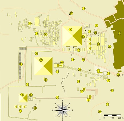
La meseta de Giza
Descripción las principales edificaciones de la meseta de Giza: 29° 58′ 33″ N 31° 07′ 49″ E
Mapa de la meseta de Giza
1. La Gran Pirámide de Giza
2. La pirámide de Jafra
3. La pirámide de Menkaura
4. El templo funerario de Jafra
5. El templo funerario de Jufu y Menkaura
6. La pirámide subsidiaria de Jufu
7. El templo del Valle de Jafra
8. El templo del Valle de Menkaura
9. Las tumbas de la reina Hetepheres
10. La mastaba de la reina Jentkaues
11. Las pirámides de la reinas de Menkaura
12. Las mastabas de cortesanos de Jafra
13. La Gran Esfinge
14. El templo de la Esfinge
15. La mastaba de Hemon
16. Las mastabas occidentales
17. El control de entrada (actual)
18. Los fosos de las barcas solares
19. Carretera de acceso (actual)
20. Las tumbas hipogeos
21. Almacenes de los artesanos
22. Carretera de acceso (actual)
23. Nazlet el-Samman
24. Calzadas procesionales
25. La cantera de Menkaura
26. El cementerio (actual)
27. Las tumbas hipogeos del sur
28. Muros perimetrales
29. Mastabas y tumbas hipogeos
30. El cementerio de mastabas occidetal
31. El cementerio de mastabas oriental
(2) Giza
Giza or Gizah (Arabic, الجيزة, transliterated al-Gīzah; pronounced in the Cairene dialect of Egyptian Arabic eg-Gīza; also sometimes rendered in English as Gizeh, Ghizeh, or Geezeh) is a town in Egypt on the west bank of the Nile river, some 20 km southwest of central Cairo and now part of the greater Cairo metropolis. It is the capital of the Al Jizah Governorate, and is located near the northeast border of this governorate in coordinates 29°59′00″N, 31°08′00″E. It is located right on the banks of the Nile River. Its population is 4,779,000 (1998).
Giza is most famous as the location of the Giza Plateau: the site of some of the most impressive ancient monuments in the world, including a complex of ancient Egyptian royal mortuary and sacred structures, including the Great Sphinx, the Great Pyramid of Giza, and a number of other large pyramids and temples.
The Great Pyramid of Giza was once advocated (1884) as the location for the Prime Meridian, a reference point used for determining a base longitude.
History
Giza's most famous archaeological site, the Giza Plateau, holds some of the most astonishing monuments in Egyptian history. Once thriving with the Nile that flowed right into the Giza Plateau, the Pyramids of Giza were built overlooking the ancient Egyptian capital of Memphis, which was near modern day Cairo.
The Giza Plateau is also home to many other Ancient Egyptian monuments, including the tomb of Pharaoh Djet of the First dynasty as well as that of Pharaoh Ninetjer of the Second dynasty.
The city itself has seen some changes over time. Changes in infrastructure during the different occupations of Egypt by various rulers, including the British in the 19th and early 20th century, focused on the construction of roads, streets, and buildings in the area. It is commonly misunderstood that the Giza area is a complete desert area; however, Giza has become a thriving centre of Egyptian culture and is quite heavily populated, with many facilities and buildings in the current area. Giza saw much attention in particular to its vast amount of ancient Egyptian monuments found on the Giza Plateau, and has astonished thousands of visitors and tourists over the years. Giza's infrastructure saw much attention from both the British government prior to the 1952 coup d'etat, as well as the current Egyptian government due to the city's importance in tourism.
Parts of Giza include Alharam famous in the past for its night clubs, Zamalek predominantly populated by middle class Egyptians and relatively recently overpopulated Almohandeseen.
Texto: Wikipedia

2 comentarios
victor -
mariana de los santos -